
We’re pleased to announce that Entgra MDM has yet another new feature – geofencing capabilities. Enterprise Mobility Management (EMM) admins can define required virtual perimeters for controlling access over specified boundaries and perform some operations to those which are inside of those boundaries. Geofencing is a very useful feature in governing access for user groups. It can be conveniently set up by drawing boundaries over areas on the map.
Let’s discuss how the geofencing capabilities work through an example. Imagine that the Ministry of Education wants to provide tablets or mobile devices for school children in rural areas for online learning during the pandemic. And they wish to provide all the learning materials to the devices and manage those device capabilities. Additionally, they want to ensure that these devices do not leave school premises. The Ministry can use geofencing capabilities to monitor the devices’ locations, manage capabilities, and perform certain actions.
The Functionality of Geofencing Capabilities
Before you create a geofence, you need to set up the Alerting Configurations under the Platform Configurations. You can provide an email address where you can receive alerts. According to your use case, you can define whether users cross or access boundaries.
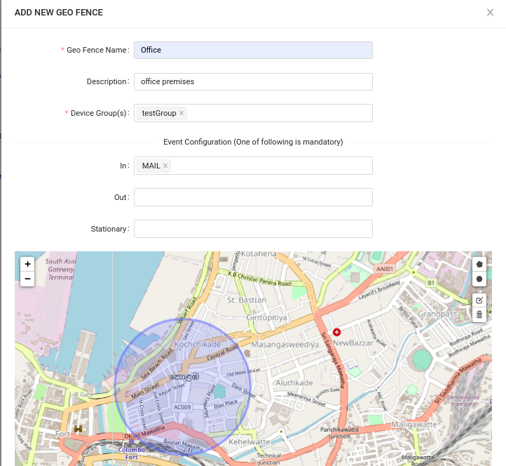
After defining the configurations you will be able to create geofences in Entgra MDM. The following data should be provided to create a new geofence.
- Geofence name: Provide a name for identifying the geofence
- Description: Add more details about the geofence
- Device group(s): Assign a group (or groups) that consists of the devices that need to belong to the geofence
- Event configurations: Add the given alert configuration to the relevant field
Afterwards, you need to mark the boundary line on the map. By using a shape such as a polygon or a circle, mark the area that you want to define as the geofence and then click on the Create button. The geofence table lists all the geofences that you create.
Returning to our example, after creating a geofence by including the school boundaries, if one of the students tries to leave the school with a device, the head of the school receives an alert and he/she can track the device location. The head of the school can also view how many devices in the relevant geofence are active at any given time. In addition, it can check the location of the provided devices and the device count, preventing devices from being misplaced.
Not only that, the group (or groups) that created the geofence can apply the required educational materials at the same time, adding various restrictions to the devices and managing them.
Entgra MDM has extensive enterprise wide MDM features that you can customize for your business needs. Learn more about the product and how we can help here.
You can also get in touch with us via contact@entgra.io